| Reference: | S44865 |
| Author | Johannes de Laet |
| Year: | 1625 ca. |
| Zone: | Paraguay |
| Printed: | Leyden |
| Measures: | 360 x 285 mm |
| Reference: | S44865 |
| Author | Johannes de Laet |
| Year: | 1625 ca. |
| Zone: | Paraguay |
| Printed: | Leyden |
| Measures: | 360 x 285 mm |
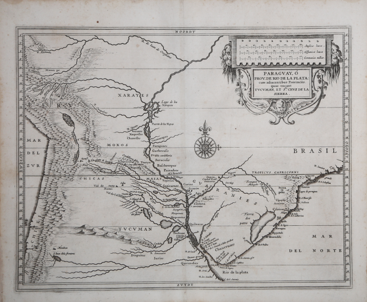
The map covers the middle third of the South American continent around the mouth of the Rio de la Plata and includes portions of the present-day countries of Peru, Brazil, Paraguay, Uruguay, Chile and Argentina, but at the time of publication the area was part of the colonial claims shared by Portugal and Spain. Place names identify a variety of colonial settlements, indigenous towns, missions and more. The Andes are prominently represented and named along the left side of the map, along with Lake Titicaca and other prominent geographical features.
The map was published in Leiden in 1630 as part of Johannes de Laet's Nieuwe Wereldt often Beschrijvinghe van West-Indien (Description of the West Indies ). The work was originally published in 1625 and contained ten maps; this is the slightly updated version that contained fourteen maps and 100 more pages of text, reflecting the growing interest of the Dutch in the New World.
Described by Philip Burden as "probably the finest description of the Americas published during the seventeenth century," the maps in de Laet's work were based directly on the cartography of Hessel Gerritsz, an engraver's apprentice to W. J. Blaeu before starting his own business. He was then appointed cartographer to the Dutch East India Company and later held the same position in the newly formed West India Company. Although Gerritsz actually visited the area during his trip to South America and the West Indies undertaken in 1628, this map obviously lacks first-hand knowledge, except along the coast.
Johannes de Laet used meticulous research and contemporary sources to compile his geographical data. As director of the newly formed Dutch West India Company, he also made use of the latest information from private correspondence, manuscripts, and other company secrets when compiling the maps.
Gerritsz' map served as a model for other cartographers throughout the rest of the century.
Johannes de Laet(1581 - 1649
Johannes de Laet(1581 - 1649