- New

| Reference: | S48765 |
| Author | Johannes VAN KEULEN |
| Year: | 1680 ca. |
| Zone: | Brazil |
| Printed: | Amsterdam |
| Measures: | 585 x 515 mm |
| Reference: | S48765 |
| Author | Johannes VAN KEULEN |
| Year: | 1680 ca. |
| Zone: | Brazil |
| Printed: | Amsterdam |
| Measures: | 585 x 515 mm |
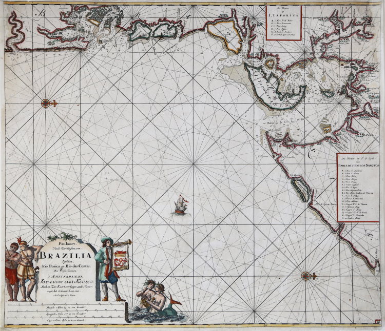
Beautiful nautical chart of the Brazilian Atlantic coastline, first published in the 1680 edition of De Groote Nieuwe Vermeerderde Zee-Atlas ofte Water-werelt (see Koeman, AN, vol. IV, p. 282), and replicated in the same year in the French edition, entitled Le Grand Nouvel Atlas de la Mer (Koeman, Keu 2).
Borders graduated for latitude. Bar scales in Dutch miles, Spanish miles and English and French miles. Shows the location of the Tapiana silver mine and numerous settlements.
The Van Keulen dynasty of publishers, book merchant printers and cartographers produced the most complete and up-to-date Dutch nautical atlases. Johannes van Keulen (1654 - 1715) established a book and instrument sales business in Amsterdam in 1678 and in 1680 was granted the privilege by Holland and West Friesland to print nautical guides and atlases. His first major work was the Nieuwe Lichtende Zee-Fakkel, illustrated by Jan Luyken, with maps drawn by Claes Jansz Vooght; five volumes were published between 1681 and 1684. Van Keulen also produced a Zee-Atlas ofte Water-werelt. The Van Keulen business continued for nearly two centuries; Gerard (1678 - 1726) produced new editions of his father's works, numerous manuscript maps, and in 1706 was appointed hydrographer of the Dutch East India Company (VOC); his son Jan II van Keulen (1704 - 1770) took over the business in 1726 and published a new edition of the Asian volume of the Zee-Atlas; he was appointed cartographer of the VOC in 1743.
Etching, finely hand-colored, restorations to upper corners, otherwise in very good condition.
Bibliografia
Koeman, Bibliography of terrestrial, maritime and celestial atlases and pilot books, published in the Netherlands up to 1880, 152.
Johannes VAN KEULEN (1654 - 1715)
|
As we have noted in other biographies in this chapter, the Dutch produced a remarkable number of enterprising and prolific map and chart makers but not even the Blaeu and Jansson establishments could rival the vigour of the van Keulen family whose business was founded in 1680 and continued under their name until 1823 and in other names until 1885 when it was finally wound up and the stock dispersed at auction.
Throughout the history of the family, the widows of several of the van Keulens played a major part, after their husbands' deaths, in maintaining the continuity of the business.
The firm was founded by Johannes van Keulen who was registered as a bookseller in Amsterdam in 1678. In 1680 he published the first part of his Zee Atlas which, over the years, was expanded to 5 volumes and continued in one form or another until 1734. More ambitious and with a far longer and more complicated life was his book of sea charts, the Zee-Fakkel, published in 1681-82 which was still being printed round the year 1800. A major influence in the development of the firm was the acquisition in 1693 of the stock of a rival map publisher, Hendrik Doncker.
Although the firm was founded by Johannes van Keulen, he was primarily a publisher; it was his son, Gerard, a talented engraver, mathematician, Hydrographer to the East India Company, who became the mainspring of the business which not only published charts but also books on every aspect of geography, navigation and nautical matters.
|