

| Reference: | S39995.13 |
| Author | Pierre DUVAL |
| Year: | 1656 ca. |
| Zone: | Southern America |
| Printed: | Paris |
| Measures: | 123 x 100 mm |


| Reference: | S39995.13 |
| Author | Pierre DUVAL |
| Year: | 1656 ca. |
| Zone: | Southern America |
| Printed: | Paris |
| Measures: | 123 x 100 mm |
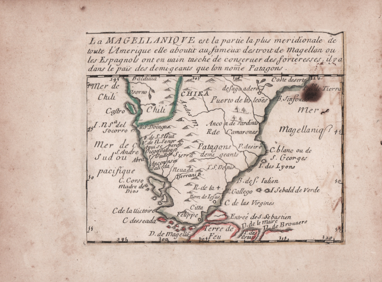
Etching, circa 1656, with contemporary outline colour, good condition.
Example of the second state of two, with the imprint of Jacques Lagniet and the date 1661.
The map comes from the very rare sheet entitled “L’Amerique par P. Du Val Geographe du Roy”, from which it was cut at the time and laid down on contemporary laid paper support, to form a small atlas, as certified by the ancient ink inscriptions on some of the maps.
According with Philip Burden “The purpose of this rare curiosity by Pierre Duval is not known. It forms part of a set of the four known continents. It can be dated to apporximately 1656 […] The only example of the first state known to the author come from the John Evelyn Library in the early 1980s. The second state bears the additional imprint of Jacques Lagniet and the date 1661”. (cf. Burden, The Mapping of North America, pp. 417-418, n. 322). Burden list only 2 example of the second state, in a private American collection (The Glen McLaughlin Map Collection of California as an Island, at Stanford University) and at the Bibliotheque National de France (that own all the set of four continents).
Pierre Duval's compilation of American maps is both rare and unusual. The sheet contains 18 individual maps of various parts of North and South America. The general map at top left is drawn from Duval's own folio map of 1655, which features the island of California, no Great Lakes, and a large Terre de Iesso stretching between Asia and North America.
There are eight devoted to North America; four of which are based on Sanson's maps of 1656 - Le Canada, La Nle. Espagne, Le N. Mexique, and La Floride. Burden's comparison with Sanson's maps leads him to believe that Duval's map may have preceded Sanson's Audience de Guadalajara or possibly were published concurrently, making this map of New Mexico actually the first devoted to the island of California. Interestingly, on the small map the island is presented on the Foxe model, while on the general map it is shown on the Briggs format. The four small maps along the center of the bottom row - La Virginie, La Nle. Holande, La Nle. Suede, and Le Nouveau Danemarq are extremely interesting because there are few contemporary maps devoted to these regions. The map of New Holland features the lower part of the R. del Nort (Hudson River). The map of New Sweden is the first map to focus on the Delaware River. The map of New Denmark depicts the Arctic region claimed by Denmark to the northwest of Hudson Bay, here labeled Mer Christiane.
The other maps on the sheet include two devoted to the West Indies, and seven regional maps of South America - La Guiane, La Castille d'Or, Le Perou, Le Bresil, Le Chili, Le Paraguay, and La Magellanique.
|
Burden, The Mapping of America, n. 322, II/II; Pastoureau (1984) p. 136; cf. Betz, The Mapping of Africa, pp. 294, 295, n. 85; cf. J. Hubbard, Japoniae Insulae. The Mapping of Japan, pp. 199-201, n. 28.
|
Pierre DUVAL(1618 - 1683)
|
Burden, The Mapping of America, n. 322, II/II; Pastoureau (1984) p. 136; cf. Betz, The Mapping of Africa, pp. 294, 295, n. 85; cf. J. Hubbard, Japoniae Insulae. The Mapping of Japan, pp. 199-201, n. 28.
|
Pierre DUVAL(1618 - 1683)