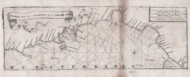


| Reference: | CO-416 |
| Author | Vincenzo CORONELLI |
| Year: | 1707 |
| Zone: | Tirreno Meridionale |
| Printed: | Venice |
| Measures: | 405 x 140 mm |


| Reference: | CO-416 |
| Author | Vincenzo CORONELLI |
| Year: | 1707 |
| Zone: | Tirreno Meridionale |
| Printed: | Venice |
| Measures: | 405 x 140 mm |
Carta nautica del Mar Tirreno meridionale. Orientata con l’est in alto, come enunciato dal titolo si estende dal Circeo a nord (in realtà comprende anche Anzio e Nettuno) fino allo Stretto di Messina.
Opera tratta dal volume sul Regno di Napoli del rarissimo Teatro della Guerra diviso in XXXXVIII parti di Vincenzo Coronelli, edito a Venezia (sebbene nel frontespizio sia indicato Napoli) tra il 1706 ed il 1709.
La raccolta comprende centinaia di vedute, carte geografiche e nautiche di tutte le parti del mondo.
Come scrive Ermanno Armao, grande studioso del Coronelli, “non è facile stabilire quanti e quali sono i volumi che compongono la raccolta". Secondo Augusto De Ferrari (cfr. Dizionario Biografico degli Italiani - Volume 29, 1983): “il Teatro della guerra era previsto in quarantotto volumi, ma ne uscirono solo ventisette a Venezia tra il 1706 e il 1709, anche se recano diverse indicazioni, ed intendeva essere una descrizione geografica degli Stati coinvolti nella guerra di successione spagnola, con poche pagine di testo e molte tavole (circa duemila), non tutte originali”.
Alcune carte derivano da quelle già incluse nel testo dell'Isolario del 1696, con alcune varianti – spesso nella dedica. La maggior parte delle vedute viene tuttavia realizzata appositamente per l'opera.
Acquaforte, leggera ossidazione lungo la piega verticale a destra, per il resto in perfetto stato di conservazione. Carta molto rara.
Vincenzo CORONELLI (Venezia 1650 - 1718)
|
Cosmographer, geographer, biographer, encyclopedist, globe maker, inventor, expert of engeneering and hydraulics. Extraordinarily versatile mind and an extremely tireless man, he produced more than 140 pieces in different genres. At the age of 15, he entered the Franciscan Order, which he then guided as Gran Generale from 1699. He became famous as geographer and mathematician, awakening the interest in these subjects in Italy at the end of the XVII century. He travelled a lot, seeking for all that was new, and keeping a correspondance with the most important intellectuals of his time. In 1681 Louis XIV wanted him to go to France, to entrust him with the task of making two terraqueous globes (Marly Globes), with a diameter of 4 metres. Once he came back to Italy, in 1685, he became Cosmographer of the Venetian Republic, where he taught geography and founded the first geographic accademy, called The Argonauts Accademy. In his whole life he produced more that 500 maps; some of them can be found in his most famous works, such as the Venetian Atlas (1690), the Island Book of the Venetian Atlas (1696-97), the Book of Globes (1693). As far as his scientific method, he didn’t elaborate new cartographic systems, but followed the theories that were considered most popular and effective at his time, based on the Copernican system. The main characteristic of his charts is the high quantity of toponymic and historical information. In his most famous and dense work, the Venetian Atlas, we can find about 1100 plates, 200 of which are extremely technical and this is the reason why it is considered the first Italian atlas to describe and illustrate the whole world with charts and maps. It was published in 13 volumes, starting from 1690, and it took nearly ten years to finish it. It is divided in different parts, the most important are the Atlas itself, then the Island Book, the Corso Geografico and the Teatro delle città.
|