
| Reference: | S13147 |
| Author | Gilles Robert de VAUGONDY |
| Year: | 1789 ca. |
| Zone: | Northern Italy |
| Printed: | Paris |
| Measures: | 310 x 270 mm |
| Reference: | S13147 |
| Author | Gilles Robert de VAUGONDY |
| Year: | 1789 ca. |
| Zone: | Northern Italy |
| Printed: | Paris |
| Measures: | 310 x 270 mm |
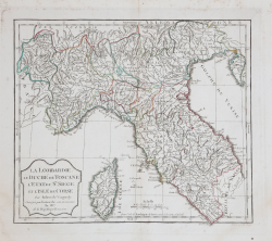
Carta geografica del nord e centro Italia.
Tratta da "Nouvel atlas portatif destine principalement pour l’instruction de la jeunesse" seconda edizione del "piccolo" atlante di Vaugondy, corretto da Delamarche, 1789.
Incisione in rame, coloritura coeva dei contorni, in ottimo stato di conservazione.
Gilles Robert de VAUGONDY (1688 - 1766)
|
Didier Robert de Vaugondy (1723-1786) was appointed Geographer to Louis XV in 1760. At the same time, de Vaugondy served as Geographer to the Duke of Lorraine and Bar, father-in-law to Louis XV and former King of Poland.
His major contributions to French cartography are the Atlas Universel, 1750-57, The Nouvelle Atlas Portatif (1784) and a very popular map of North America published in 1761. He was son of Gilles Robert de Vaugondy who succeeded Pierre Sanson as the King's Geographer.
|