
| Reference: | MS3818 |
| Author | Guillaulme DE L'ISLE |
| Year: | 1703 ca. |
| Zone: | Mexico, Florida |
| Printed: | Paris |
| Measures: | 660 x 485 mm |
| Reference: | MS3818 |
| Author | Guillaulme DE L'ISLE |
| Year: | 1703 ca. |
| Zone: | Mexico, Florida |
| Printed: | Paris |
| Measures: | 660 x 485 mm |
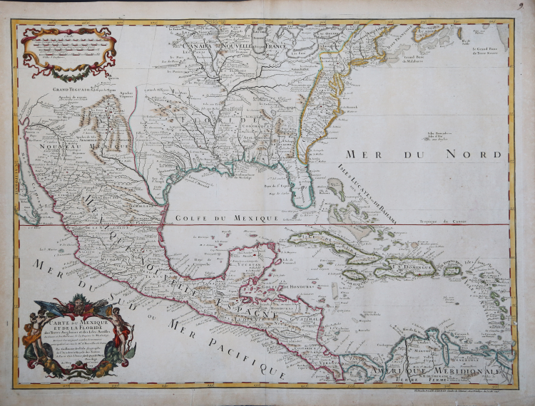
Carte du Mexique et de la Floride des Terres Angloises et des Isles Antilles du Cours et des Environs de la Riviere de Mississipi. Dressée sur un grand nombre de memoires principalemt. sur ceux de ... d'Iberville et le Sueur. Paris: Chez l'Auteur le Sr. Delisle sur le Quai de l'Horloge, 1703 [1708].
A good copy of the second state (of five) of this 'towering landmark along the path of Western cartographic development' (Wheat): the first printed map 'to portray accurately the course and mouth of the Mississippi River.' (Martin).
According to William Cumming, De L'Isle's address in the first state of this map reads 'Rue des Canettes pres de St. Sulpice', the second issue address (as here) reads 'sur le Quai de l'Horloge'. '
“At the time De L'Isle prepared his new map of Mexico and Florida, published in 1703, much new information on the area had become available since Coronelli's effort fifteen years before. Firsthand reports from the survivors of Lasalle's expedition, as well as from the French explorers and colonizers of the Gulf region like Bienville and d'Iberville, were carefully studied ... [The present map] was the first printed map to portray accurately the course and mouth of the Mississippi River. He correctly depicted the Great Lakes region, as well as the many English settlements along the East Coast. He also carefully set down the explorations of d'Iberville and his men on the gulf Coast and the lower reaches of the Mississippi and Red rivers, and the Indian villages in East Texas where the Spanish constructed their missions and presidios. The present-day region of Texas and Oklahoma was portrayed as part of "Floride," a French posession, the name of which in later maps was changed to Louisiana' (James C. Martin Maps of Texas and the Southwest, 1513-1900 p.93). De L'Isle's maps were regarded as quasi-official documents that reflected the opinions and policies of the French government. For this reason, his expansion of the French territorial claims at the expense of Britain and Spain caused great alarm in London and Madrid. He pushed Spanish America west to the Pecos River, therefore laying claim to Texas and the Great Plains for France, and the English colonies were restricted to a narrow strip on the eastern side of the Appalachian Mountains. Guillaume de l'Isle (1675-1726), or De L'Isle, was the son of a cartographer and a pupil of Jean Dominique Cassini, who, among other important contributions, aligned the study of astronomy to the study of geography. Under Cassini's direction, observations were made from locations all over the world that enabled longitudinal calculations to be made with much greater accuracy. DeL'Isle carried on this exacting work with remarkable dedication and integrity, constantly revising and improving his maps. While precision was his primary goal, his maps are invariably elegant and attractive. 'He has often been cited as the first truly scientific cartographer, and his maps were widely copied by the commercial ateliers of Paris, Amsterdam, and the rest of Europe. He was elected to the French Academy of Science in 1702 and in 1718 was named "Premier Geographe du Roi," a title created especially for him' (James C. Martin Maps of Texas and the Southwest, 1513-1900 p. 93).
Guillaume de L'Isle (1675-1726) was the Geographer Royal to both Kings Louis XIV and Louis XV. Of a brilliant and precocious mind, while still only in his 20s, De L'Isle established himself as the leading cartographer in France, then the epicenter of mapmaking in Europe. With his unrivaled access to both official French government and Jesuit sources, De L'Isle was able to devise maps of North America which were dramatically more advanced than those of his contemporaries, of which the present map is a prime example.
Copper-engraved map, hand-coloured in outline, fine condition.
Bibliografia
Bryan & Hanak Texas in Maps 10; Cumming Southeast in Early Maps, 137; Alfred E. Lemmom and others (editors) Charting Loiusiana p.39; James C. Martin Maps of Texas and the Southwest 1513-1900 p.93; Schwartz & Ehrenberg, The Mapping of America, p.137; Wagner The Cartography of the Northwest Coast of America 474; Wheat Mapping the Transmississippi West 84.
Guillaulme DE L'ISLE (1675 - 1726)
|
vershadowed by his more famous son, Guillaume.
Guillaume De L’Isle, (1675-1726) Premier Geographe to the French king, was probably the leading map-maker of the period. His work was important as marking a transition from the maps of the Dutch school, which were highly decorative and artistically-orientated, to a more scientific approach, which reduced the importance given to the decorative elements, and emphasized the scientific base on which their maps were constructed, out of which the modern school of cartography emerged. He was prominent in the recalculation of latitude and longitude, based on the most up-to-date celestial observations, and his major contribution was in collating and incorporating this information in his maps, setting a new standard of accuracy, quickly followed by many of his contemporaries, including the Dutch firm of Covens and Mortier.
Having learnt geography from his father, it is said that at the age of eight or nine he could draw maps to demonstrate ancient history. He studied mathematics and astronomy under J.D. Cassini, where he received the grounding in scientific cartography, that is the hallmark of his work.
His first atlas was published in about 1700, in 1702 he was elected a member of the Academie Royale des Sciences, and in 1718 became Premier Geographe du Roi. His maps of the newly explored parts of the world reflect the most up-to-date information available and did not contain fanciful detail in the absence of solid information.
After his death in 1726 his business was continued by his nephew Philippe Buache, and subsequently by J. Dezauche.
Joseph Nicholas De L’Isle (1688-1768), Guillaume’s brother, became a friend of Peter the Great and supplied him with information on the Russian Empire. He stayed in Russia for twenty-two years and was in charge of the Royal Observatory in St. Petersburg, returning to France in 1747, taking with him much of the material he had access to, particularly relating to explorations along the northern Pacific coasts of Russia and America, which he subsequently published. The Atlas Russicus was published in 1747 and contained twenty maps.
Simon Claude De L’Isle (1675-1726) was a historian. It is curious to note that he was born and died in the same years as his elder brother Guillaume.
|