| Reference: | S45973 |
| Author | Nicolas SANSON |
| Year: | 1652 |
| Zone: | The World |
| Printed: | Paris |
| Measures: | 540 x 400 mm |
| Reference: | S45973 |
| Author | Nicolas SANSON |
| Year: | 1652 |
| Zone: | The World |
| Printed: | Paris |
| Measures: | 540 x 400 mm |
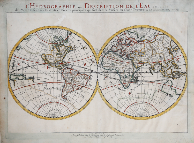
L'Hydrographie ou Descriprion de L'Eau c'est a dire des Mers, Golfes, Lacs, Destroits, et Rivieres principales, qui font dans la Surface du Globe Terrestre.
Double hemisphere world map showing the rivers and water bodies of the world. One of the earliest of Sanson's world maps and one of the earliest obtainable maps to show the five Great Lakes. The map is based upon Sanson's 1651 map of the world (Shirley 390), but with more prominence given to marine and river features. California is shown as an island. Depicts Australia prior to Tasman's discoveries, and labels North Australia "Beach" according to Marco Polo, and California as an island.
In this map Sanson has renamed Nouvelle Albion in the northwest part of North America as Terra de Iesso and the Detriot d'Anian has been moved to just north of California. Australia is only partially shown, still marked Beach (after Marco Polo), and there is a faint outline of the southern continent labeled Terre Australe Magellanique & Incogneue. The curious massive land mass which nearly connected Asia and the northwest coast of America is also shown in a faint outline, which is very different than illustrated in Shirley 390. There is no known explanation for this landmass, which extends to Niphon and would nearly double the size of the usual landmass shown in this area on Sanson's other world maps.
Nicolas Sanson was cartographer extraordinaire and geographer to Louis XIII. Sanson's principal historical importance lies in his role as a disseminator of knowledge: 'His maps, geographical tables and teaching captured the attention of persons no less eminent than Richelieu, Fouquet, the chancellor Seguier, and Cardinal Mazarin…The regard of such illustrés reveals Sanson as an important conduit of geographical knowledge to centres of power in France, which at this time was at its most important period of expansion in Canada, the West Indies, Africa, and the Near East' (Pedley, Imago Mundi 44).
A fine example with full later hand colour, very good condition.
Bibliografia
Shirley, R.W., Mapping of the World, n. 394.
Nicolas SANSON (Abbeville 1600 - Parigi 1667)
|
Nicolas Sanson (December 20, 1600 - July 7, 1667) and his descendants were the most influential French cartographers of the 17th century and laid the groundwork for the Golden Age of French Cartography. Sanson was born in Picardy, but his family was of Scottish Descent. He studied with the Jesuit Fathers at Amiens. Sanson started his career as a historian where, it is said, he turned to cartography as a way to illustrate his historical studies. In the course of his research some of his fine maps came to the attention of King Louis XIII who, admiring the quality of his work, appointed Sanson Geographe Ordinaire du Roi. Sanson's duties in this coveted position included advising the king on matters of geography and compiling the royal cartographic archive. In 1644 he partnered with Pierre Mariette, an established print dealer and engraver, whose business savvy and ready capital enabled Sanson to publish an enormous quantity of maps. Sanson's corpus of some three hundred maps initiated the golden age of French mapmaking and he is considered the 'Father of French Cartography.' His work is distinguished as being the first of the 'Positivist Cartographers,' a primarily French school of cartography that valued scientific observation over historical cartographic conventions. The practice result of the is less embellishment of geographical imagery, as was common in the Dutch Golden Age maps of the 16th century, in favor of conventionalized cartographic representational modes. Sanson is most admired for his construction of the magnificent atlas Cartes Generales de Toutes les Parties du Monde. Sanson's maps of North America, Amerique Septentrionale (1650), Le Nouveau Mexique et La Floride (1656), and La Canada ou Nouvelle France (1656) are exceptionally notable for their important contributions to the cartographic perceptions of the New World. Both maps utilize the discoveries of important French missionaries and are among the first published maps to show the Great Lakes in recognizable form. Sanson was also an active proponent of the insular California theory, wherein it was speculated that California was an island rather than a peninsula. After his death, Sanson's maps were frequently republished, without updates, by his sons, Guillaume (1633 - 1703) and Adrien Sanson (1639 - 1718). Even so, Sanson's true cartographic legacy as a 'positivist geographer' was carried on by others, including Alexis-Hubert Jaillot, Guillaume De L'Isle, Gilles Robert de Vaugondy, and Pierre Duval.
|