

| Reference: | S46330 |
| Author | Nicolas VISSCHER I |
| Year: | 1663 ca. |
| Zone: | The World |
| Printed: | Amsterdam |
| Measures: | 475 x 310 mm |


| Reference: | S46330 |
| Author | Nicolas VISSCHER I |
| Year: | 1663 ca. |
| Zone: | The World |
| Printed: | Amsterdam |
| Measures: | 475 x 310 mm |
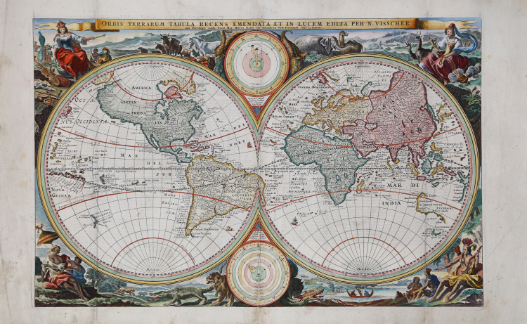
Superb double hemisphere world map, surrounded by engravings including allegorical representations of the continents (Europe, Asia, Africa and America) as well as native inhabitants and wildlife. Visscher’s decorations were so popular several other cartographers copied them. Two diagrams depicting the Ptolemaic and Copernican theories of the solar system appear within the cusps of the hemispheres. The northwest coast of North America is greatly exaggerated with the fictional El Streto d’Anian, while California is shown as a peninsula. In the Pacific, Western Australia, Van Diemens Landt, and a bit of New Zealand are also noted.
Second state of Visscher's double hemisphere map of the world, which includes many of the great 17th Century cartographic myths and errors. A massive land extension north of California reaches nearly to Asia and shows the Straits of Anian and NW Passage, with dozens of early place names on the NW Coast, including Quivira Regnum, which appears twice: one just opposite the Straits of Anian and once just east of the Rio Grande River. North America is misconfigured in a manner similar to early world maps by Hondius. A partial New Zealand and Australia both appear. The tracks of Magellan's circumnavigation are shown, along with other cartographic misconceptions.
The present map is Visscher's second world map to appear in a Bible, after his map of 1657. The map exists in 2 states, the first state and this second state, which includes a note granting Visscher a 15-year privilege, which appears directly below the title. The map was prepared for an Elzevir Bible. As noted by Shirley, "the allegorical scenes in the corners are ... presented in a more polished and artistic fashion."
Visscher's Bible map was probably the single most copied world map of the 17th and 18th Century, with a number of different engravers copying the cartography and decorative elements for nearly 100 years. Per Shirley, it also appeared in some of De Wit's early atlases.
Etching with fine later hand colour, small repairs among the central fold, otherwise very good condition.
Bibliografia
Shirley, Mapping of the World, n. 431.
Nicolas VISSCHER I (1618 - 1679)
|
For nearly a century the members of the Visscher family were important art dealers and map publishers in Amsterdam. The founder of the business, C. J. Visscher, had premises near to those of Pieter van den Keere and Jodocus Hondius whose pupil he may have been. From about 1620 he designed a number of individual maps, including one of the British Isles, but his first atlas consisted of maps printed from plates bought from van den Keere and issued as they stood with some additions of his own, including historical scenes of battles and sieges for which he had a high reputation. Some maps bear the latinized form of the family name: Piscator. After Visscher's death his son and grandson, both of the same name, issued a considerable number of atlases, constantly revised and brought up to date but most of them lacking an index and with varying contents. The widow of Nicholaes Visscher II carried on the business until it finally passed into the hands of Pieter Schenk.
|