

| Reference: | ms4134 |
| Author | Società CALCOGRAFICA |
| Year: | 1799 |
| Zone: | The World |
| Printed: | Venice |
| Measures: | 665 x 515 mm |


| Reference: | ms4134 |
| Author | Società CALCOGRAFICA |
| Year: | 1799 |
| Zone: | The World |
| Printed: | Venice |
| Measures: | 665 x 515 mm |
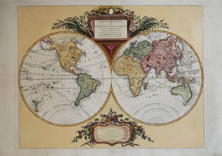
A large double-hemisphere map with ornate cartouches in each cusp. Published after Cook's first circumnaviation it has been updated with his discoveries: New Zealand is shown properly as two main islands and the east coast of Australia has been corrected, although still with Tasmania connected to the mainland.
In the North Pacific the spurious North West Passage is shown. This very rare map belongs to a never finished project for the atlas of the so called Società Calcografia, a simple commercial trade realized by the two main Venetian publishers of the XVIII century, Antonio Zatta and Giuseppe Antonio Remondini. The term Società Calcografica has been deduced from the map of the world, which is part of the collection and bears in the lower cartouche the French writing “à Venise Chez la Societè Chalcographique 1799”.
As already stated, the project was never finished for no atlas containing these maps has ever been listed in any bibliography. Very likely, then, the maps have been sold individually, or maybe as part of smaller, custom collections. The maps of the collection derive from Paolo and Francesco Santini’s plates, used by Remondini in his 1782/4 Atlas Universelle, and from the plates of Antonio Zatta’s Nuovo Atlante published in 1796.
Santini’s maps have been beautifully enriched, using the system of small, masked plates which can be perceived through the platemarks on the paper, with great cartouches according to the classical style of Zatta and have been probably engraved by the members of his staff, Pasquali, Zuliani and Pitteri. The cartouches bear very often historical descriptions and maybe the maps have been realized to depict the great geographic changes of the peninsula during the Napoleonic period.
The modern bibliography Terre di Langobardia describes some of the maps depicting the Repubblica Cisalpina, presenting them as part of Remondini’s “Atlas très Nouveau”, which was printed starting from 1800. In our opinion, the two publishers worked together to the realization of the project until Antonio Zatta died (1804), and the complete atlas was never finished because Giuseppe Antonio Remondini also died in 1811. I personally know 61 maps which were part of the project.
Copper engraving, fine hand color, in excellent condition.
Società CALCOGRAFICA (1799 - 1805)
|
ANTONIO ZATTA (Venezia 1722 – 1804) A Venetian cartographer, typographer, publisher and book dealer. In his workshop, together with his sons, he worked mainly to the realization of geographic maps and atlases, together with many important books of the classical tradition. In his production, the chalcographic output played an important role (especially front pages, decorations, vignettes, portraits), also thanks to his brother Giacomo and to Pietro Antonio Novelli. 1779-85 Atlante Novissimo, Illustrato ed Accresciuto sulle osservazioni e scoperte fatte dai più celebri e più recenti geografi. Published in Venice by Antonio Zatta; 1799 New Atlas
GIUSEPPE ANTONIO REMONDINI The Remondini printing business is a famous publishing house who dealt mainly in folk prints and books. It was founded in 1661 in Bassano and was active until 1860. Giovanni Antonio Remondini (1634 - 1711) was the founder, but it was with Giuseppe Remondini (1745 - 1811) and his sons, in the second part of the Eighteenth century, that it reached its maximum development. During that period, the typography has been competing with those in Augsburg and Paris, selling its production all over Europe.
|