

| Reference: | S24813 |
| Author | Hans LUFT |
| Year: | 1534 ca. |
| Zone: | Daniel's Dream Map |
| Printed: | Wittenberg |
| Measures: | 155 x 115 mm |


| Reference: | S24813 |
| Author | Hans LUFT |
| Year: | 1534 ca. |
| Zone: | Daniel's Dream Map |
| Printed: | Wittenberg |
| Measures: | 155 x 115 mm |
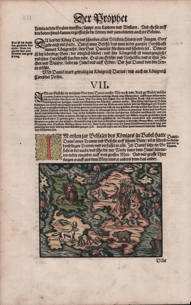
Woodcut map with fine colouring, set in a text page of a Bible printed in Wittenberg.
A rare edition of this somewhat curious map of Europe, Africa, and Asia is to be found in apocalyptic literature originally emanating from Wittenberg in 1530 or even 1529. The map was first used by the printer Hans Luft to illustrate two works: one a commentary on the prophet Daniel by Martin Luther (1530) and another linking the vision of Daniel with the assaults of the Turks on the perimeters of Christian Europe at the time.
The wood cut map is showing the four beasts of Daniel's Dream Map.
The Wittenberg World Map, more commonly known in English as Daniel’s Dream Map, is probably the most mystical world map of all time. At the time of its first publication as the sixty-first world map to go into print, it was, on the one hand, a depiction of the Old World, based on the Ptolemaic world view but including a number of recent Spanish and Portuguese discoveries, but on the other, a visualization of the prophet Daniel’s apocalyptic dream of the four kingdoms. There are fourteen different versions of Daniel’s Dream Map, with twenty printing blocks. All the versions are produced in woodcut technique.
According to Ernst Gallner this is the first version of the map “The first mention of Daniel’s Dream Map is made in a commentary on the prophet Daniel by Justus Jonas and Philipp Melanchthon in December 1529 and immediately afterwards in January 1530 in an interpretation of the book of the prophet Daniel by Martin Luther, both published by Hans Lufft in Wittenberg. This version is referred to in the following as the original version. From this time on, the map appears in a number of Lutheran, German or German-influenced bibles and theological books of the 16th up to the mid.18th century, and in a book on the history of the Jews by Flavius Josephus. These later variants partially copy the original, whereby some of the artists, contrary to the wish of the time for geographical accuracy, increasingly alter the outlines of the continents, with visionary aspects taking precedence over correct cartographic depiction. The only variant to occur in a Latin bible is a schematic, abstract map by Tobias Stimmer” (cfr. The Wittenberg World Map).
|
R. W. Shirley, "The Mapping of the world", 65A; Kaarten in Bijbels, W.C. Poortman and J. Augusteijn, 1995; Eine Wittenberger Weltkarte aus dem Jahr 1529, W. Bonacker und H. Volz, 1956.
|
|
Hans Lufft was a German printer and publisher, commonly called "the Bible Printer," because in 1534 he printed at Wittenberg the first complete edition of Luther's Bible, in two quarto volumes with illuminations in gold and colors by Lucas Cranach. Lufft printed in the 40 years following more than 100,000 copies of the German Bible. He also printed most of the other works of Luther.
|
|
R. W. Shirley, "The Mapping of the world", 65A; Kaarten in Bijbels, W.C. Poortman and J. Augusteijn, 1995; Eine Wittenberger Weltkarte aus dem Jahr 1529, W. Bonacker und H. Volz, 1956.
|
|
Hans Lufft was a German printer and publisher, commonly called "the Bible Printer," because in 1534 he printed at Wittenberg the first complete edition of Luther's Bible, in two quarto volumes with illuminations in gold and colors by Lucas Cranach. Lufft printed in the 40 years following more than 100,000 copies of the German Bible. He also printed most of the other works of Luther.
|