
| Reference: | S46910 |
| Author | Antonio NIBBY |
| Year: | 1838 ca. |
| Zone: | Rome |
| Printed: | Rome |
| Measures: | 170 x 135 mm |
| Reference: | S46910 |
| Author | Antonio NIBBY |
| Year: | 1838 ca. |
| Zone: | Rome |
| Printed: | Rome |
| Measures: | 170 x 135 mm |
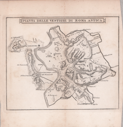
Map taken from the famous guide by Antonio Nibby, Itinéraire de Rome et de ses environs rédigé par A.N. d'après celui de M. Vasi. Nouvelle édition...enrichie de savantes observations... Rome, Proprieté d'Aug. Valentini, 1838/41.
Famous and fortunate historical-artistic guide, for the first time published in 1838 and with several reprints during the XIX century. This is the edition edited by the publisher Agostino Valentini, accompanied by two folded plans and 18 tables finely engraved by Domenico Amici and Giuseppe Cottafavi.
Antonio Nibby (Rome, April 14, 1792 - Rome, December 29, 1839) was an Italian historian, archaeologist and topographer. Of the aforementioned disciplines he laid rigorous scientific foundations based on the analysis of classical and medieval sources, the study of monuments and direct investigation on the ground. He was a scholar of topography especially of ancient Rome and the Roman Campagna.
Among his most important works are the Carta de' dintorni di Roma (1827) made together with the English archaeologist Sir William Gell, the result of five years of topographical reconnaissance in the Roman Campagna, the first archaeological map of Latium made using trigonometric methods to correctly position the various localities on the map itself; the Historical-topographical-antiquarian Analysis of the Map of the Environs of Rome (1837), a commentary on the map published in 1827, a very important work on the history and topography of the Roman Campagna; and Rome in the Year 1838, in four volumes, considered one of the best guides to the city among those written in the first half of the 19th century.
Etching, in excellent condition.
Antonio NIBBY (Roma 1792 - 1839)
|
Antonio Nibby (Rome, April 14, 1792 - Rome, December 29, 1839) was an Italian historian, archaeologist and topographer. Of the aforementioned disciplines he laid rigorous scientific foundations based on the analysis of classical and medieval sources, the study of monuments and direct investigation on the ground. He was a scholar of topography especially of ancient Rome and the Roman Campagna.
After pursuing his studies at the Roman College, on December 28, 1809, when he was only 17 years old, he founded the Hellenic Academy on December 28, 1809, with some classmates, several scholars and personalities connected with the French cultural world or who held administrative positions in Rome (at that time annexed to the French Empire) to promote studies on Greek language and literature. Due to some disagreements, however, in April 1813 twenty-six members (including the Roman poet Giuseppe Gioachino Belli) broke away from it, founding a new academy, called the Tiberina, which unlike the Hellenic was linked back to the Roman cultural tradition. When papal rule was re-established (May 24, 1814), the Hellenic Academy was suppressed, as it was considered too closely linked to the past French government, while the Tiberina Academy was able to continue its meetings. On December 2, 1815, he married Maria Valburga Viviani, a native of Lucca, by whom he had eleven children, seven of whom survive.
From 1816, having become a member of the Roman Academy of Archaeology (and later of numerous other Academies, Italian and foreign), his scientific production began: apart from Pausanias' Description of Greece (1817-1818), the only example of one of his translations (criticized by Giacomo Leopardi), his two main areas of research were the study of the topography of Rome and the Roman Campagna, and popular activity in the form of guidebooks-such as, for example, the reissue of Famiano Nardini's Ancient Rome enriched with notes and critical-antiquarian observations (1818-1820) and the Itinerario istruttivo di Roma antica e moderna [. ..] and its vicinity by Cavaliere M. Vasi antiquario romano, revised, corrected and enlarged by A. Nibby (1818), which went through numerous reprints and updates throughout the 19th century and was much appreciated by those who went to Rome on the Grand Tour - and "antiquarian journeys" (Ne' contorni di Roma, lungo la via Portuense, a Villa Adriana, at the villa of Horace and at Subiaco, in Ostia). Of this renewed guidebook, the best-known edition is the one that has images engraved by Gaetano Cottafavi and Domenico Amici.
Among his most important works are the Carta de' dintorni di Roma (1827) made together with the English archaeologist Sir William Gell, the result of five years of topographical reconnaissance in the Campagna Romana, the first archaeological map of Latium made using trigonometric methods to correctly position the various localities on the map itself; the Historical-topographical-antiquarian Analysis of the Map of the Environs of Rome (1837), a commentary on the map published in 1827, a very important work on the history and topography of the Roman Campagna; and Rome in the Year 1838, in four volumes, considered one of the best guides to the city among those written in the first half of the 19th century.
|