| Riferimento: | S46072 |
| Autore | Abraham ORTELIUS |
| Anno: | 1595 ca. |
| Zona: | Giappone e Corea |
| Luogo di Stampa: | Anversa |
| Misure: | 485 x 360 mm |
| Riferimento: | S46072 |
| Autore | Abraham ORTELIUS |
| Anno: | 1595 ca. |
| Zona: | Giappone e Corea |
| Luogo di Stampa: | Anversa |
| Misure: | 485 x 360 mm |
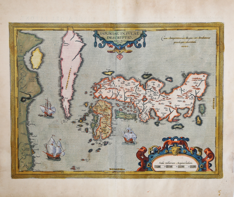
Bell'esemplare con coloritura originale della carta del Giappone di Abraham Ortelius, la prima carta dell’isola pubblicata in un atlante europeo. La mappa apparve per la prima volta nell'Additamentum Quintum del 1595, seguita dall'edizione latina del Theatrum Orbis Terrarum, il primo atlante moderno, apparsa nello stesso anno.
Ortelius incorporò informazioni derivate da Ludovico Teixeira, un cartografo e matematico gesuita portoghese. Teixeira utilizzò informazioni generate da fonti giapponesi per presentare la prima rappresentazione ragionevolmente accurata e riconoscibile del Giappone, compresi numerosi nomi di luoghi giapponesi. La Corea appare come un’isola, con la sua curiosa punta settentrionale denominata Punta dos Ladrones.
La carta è riccamente impreziosita da tre grandi galeoni, due elaborati cartigli. Questa influente mappa costituisce la base per molte altre mappe dell’isola.
Esemplare del primo stato, con la data 1595. Il secondo stato della mappa è noto per essere apparso solo nel Theatro D'El Orbe De La Tierra... M.DC.XII. [1641] con il titolo tipografico Iaponia Isla e il numero di pagina 120 (Van der Krogt 31:454).
“Before the publication of this map, the only two others based on geographic knowledge - the Cysat and the Piccaglia/Monte - were significantly inaccurate and not widely disseminated. Ortelius changed that in 1595 with the inclusion of this map in the Additamentum Quintum, followed by the Latin edition of the Theatrum in the same year. The map continued to be included in the Theatrum, unchanged, until at least the Spanish edition of 1612.
What little we know about the origins of this map and its alleged maker, Luís Teixeira, is included in the massive work by Armando Cortesão, the Portugaliae Monumenta Cartographica. In Volume III, p. 43, Cortesão quotes from a letter written by Teixeira to Ortelius advising him that he is forwarding "...two pieces of the descriptions of China and Japan, the new ones that have just arrived, truly drawn as they show."
“Luís Teixeira was one of the outstanding personalities in a family of cartographers that followed this profession through five or six generations" writes Cortesão. He was the son of Pero Fernandes, maker of charts, and both of his sons, João and Pedro Teixeira also became cartographers, working in Portugal and Spain. Teixeira was examined by Royal order, on 18 April 1564 and his patent of office was issued on 18 October 1564; there are records mentioning Teixeira as late as 1613, so his experience as cosmographer was extensive. He is known to have travelled to, and charted parts of, the coast of Brazil as well as having surveyed the Azores but there are no records of his ever having visited Japan. Teixeira's sources remain unknown, all the more surprising when we study any of the surviving portolan charts of the time, none of them being as close to reality as was this one. Although Ortelius credits Ludoico Teisera as Auctore, the text of the letter conveying the maps suggests that, as they were "...just arrived, truly drawn...". Teixeira simply conveyed someone else's work to Ortelius, bur was nevertheless given credit for it.
Ortelius's engraving of the map he received from Teixeira was the most accurate at the time. It clearly showed three of the main islands of Japan, only lacking mention of Hokkaido (Yezo or Ezo) in the north. Kyūshū was clearly shown as an island and the relative size of Shikoku was more accurate than by Cysat. The map contains a large number of place-names; one curiosity, pointed out to the present author by Michael Cooper, the author of a number of books on Japan, is Cabo]. dos Cestos, or Misakiasi the southernmost cape in the island of Honshů, and the only place name in Portuguese on any of the islands. This name (the Cape of Baskets) may have resulted from Portuguese sailors noting fishing baskets located in a place where the swirling currents delivered bountiful rewards. Teixeira's representation of Japan became the standard for most cartographers until it was replaced by Joan Blaeu's map included in the Atlas Sinensis in 1665, despite the existence of more exact knowledge of the island's cartography at the time. Abraham Ortelius (Örtel, Ortels, Hortel, Bartolus, Bartolus Arameis) (1527-1598), began his cartographic life as a map colourist and became a dealer in antiques, coins and books, in addition to maps. He published his first map in 1564, and soon after began to accumulate material for what was to become the first "Atlas", the Theatrum Orbis Terrarum, first put on sale in May of 1570 was followed by another 23 editions in his lifetime, and an additional 10 posthumously. The original edition with text in Latin was soon followed by editions in Dutch, German, French, Spanish, English and Italian.
Lach (1965) speculates that the map that Teixeira conveyed to Ortelius could have originated from sketches by Inácio Moreira, "...who first went to Japan in 1584", referencing an entry in the second volume of Cortesão and Teixeira da Mota's (1960) Monumenta. Cortesão and Teixeira da Mota in turn quote from an entry written in Nagasaki in November of 1595 and contained in one of 62 manuscript volumes Jesuits in Asia [Cod. 49-IV-56], where it states that Moreira (but erroneously written Montero) had accompanied a Jesuit to Meaco, "...and because he has been in Japan for more than two years, he very diligently sought to get the truth about the figure as well as the length and breadth of Japan..." The date of Moreira's first known stay in Japan (1584-85) would have allowed time for a map to find its way to Lisbon and then be sent on to Ortelius in 1592. As we know of no other cartographer who visited the Japanese islands at the time, the probability at least exists that Moreira had a hand in the creation of this map.
The plate remained unchanged, other than damage from wear, and included in all of the editions mentioned above, from 1595 to 1612. Ortelius's plates were sold first to Jan Baptist Vrients in 1601, secondly to the Moretus brothers after 1612; they, in turn, produced a very limited number of atlases with Spanish text differing from that in the 1612 Spanish edition. The Moretus brothers presumably erased the date '1595' from the plate sometime after 1612. Twenty-five copies of the Spanish edition were produced in 1641 with a title-page dated 1612. Loose examples of the map with the date erased either contain Spanish text on verso or are blank, an indication that the plate probably continued to be used after the production of the Spanish text atlas” (cf. Jason H. Hubbard, Japoniae Insulae The Mapping of Japan, n. 6).
Esemplare tratto dalla rara edizione italiana del Theatrum Orbis Terrarum stampata ad Anversa da Jean Baptiste Vrients nel 1608 e poi nel 1612.
Acquaforte con bella colorazione originale, ottimo stato di conservazione.
Bibliografia
Cortazzi 1983; pl. 25; Cortesão and Teixeira da Mota 1960 II: 128; Hessels 1887: letter 210; "Map Collector Circle" 36:2; Lutz Walter (1994) "Japan, a cartographic vision", p. 41, p. 212 map 5; Karrow 1993: 1/198; Van den Broecke 1996: map 165; Van der Krogt 2003: map [8450:31]; Jason H. Hubbard, Japoniae Insulae The Mapping of Japan, n. 6.
Abraham ORTELIUS (1528 - 1598)
|
Abraham Ortel, più noto come Ortelius, nacque ad Anversa nel 1528, e qui avviò un’attività come commerciante di libri e “pittore di mappe”. Viaggiò molto, specialmente per recarsi alle gradi fiere librarie, stabilendo contatti professionali e amichevoli con altri cartografi europei dai quali derivò la sua collezione di mappe. Punto cruciale nella sua carriera fu il 1564, con la pubblicazione della Mappa del Mondo in otto fogli, di cui si conosce solo una copia. Nel 1570 pubblicò, in una stessa scala, la sua collezione di mappe sotto il titolo di Theatrum Orbis Terrarum, opera che di fatto costituì il primo esempio di atlante sistematico, sebbene il termine stesso verrà usato per la prima volta da Mercator venti anni più tardi. Il Theatrum, le cui mappe furono elegantemente incise per lo più da Frans Hogenberg, ottenne un successo immediato e conobbe ben 42 edizioni in varie lingue fino a quella definitiva del 1612, inclusa l’Appendix, pubblicata di tanto in tanto, con le ultime scoperte dell’epoca. Ortelius fu anche il primo a citare le sue fonti menzionando i nomi dei cartografi. Inoltre compilò una serie di mappe storiche col titolo Parergon Theatri. L’opera, contenente anche una riproduzione della Tabula Peutingeriana, edito per la prima volta nel 1579, fu pubblicata sia separatamente sia come parte integrante del Theatrum.
|